• USD
  • EUR
  • GBP
  • AUD
  • CAD
  • ZAR

South Africa's Augrabies Falls National Park

Help Me Plan

Augrabies Falls National Park Destination Guide

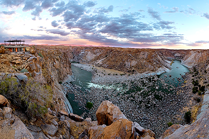
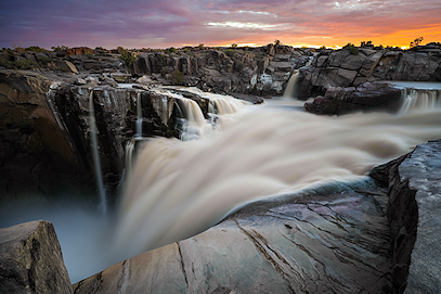
The Augrabies Falls, formed by the Orange River, are the dramatic heart of Augrabies Falls National Park. Here the river funnels through a narrow granite gorge before free-falling 56 meters into an 18-kilometer canyon. Boardwalk viewpoints, stark Nama Karoo scenery, and reliable access make this a rewarding stop for photographers, hikers, and nature lovers.

Getting There

By Air: Augrabies Falls National Park lies in a remote part of the Northern Cape. Your journey typically begins at OR Tambo International Airport in Johannesburg or Cape Town International Airport, followed by a domestic flight to Upington Airport, about 120 km from the park.

By Road: To keep travel time efficient, a private, air-conditioned vehicle and guide will meet you at Upington Airport—roughly a 90-minute drive from the falls—so you avoid the 10–11 hour drives from the major hubs.

Weather & Best Time To Visit

The region is semi-arid. Winters (late May to early September) are dry with cold nights. Summers can be extremely hot with occasional thunderstorms.

For peak water flow and more comfortable temperatures, late summer into autumn (March–May) is ideal, when the river often runs high after seasonal rains and daytime heat eases.

View of Augrabies Falls and gorge

The nearby Bridal Veil waterfall on the northern wall of the gorge provides another striking vantage point, and a network of boardwalks and trails accesses key lookouts. The multi-day Klipspringer Trail in the southern section offers superb views across the canyon and semi-desert. Guided activities can explore remote sectors of the park.

Size
820 km²
Established
1966
Province
Northern Cape
Mammal species
49
Main Waterfall
56 m
Bird species
200+
Giant aloe height
Up to 5 m
Biome
Nama Karoo

Reasons to visit Augrabies Falls National Park

1

An Ancient Culture

In one of the most uninhabitable places on the planet, people have lived along the Orange River since the Stone Age. Their descendants, the Nama, still reside in the area, and acquainting yourself with their story is deeply rewarding.

2

Desert Waters

Within the wide-open spaces and rugged rock formations of the Nama Karoo, the Orange River is a lifeline in stark contrast to the arid climate, carrying water westward to the Augrabies Falls.

3

Unique vegetation

Despite the semi-desert, plants have adapted remarkably. The giant aloe is the most iconic; standing up to five meters tall, it becomes a summer oasis as birds and insects feed on its nectar.

Start Planning

Experiences to Savor at Augrabies Falls National Park

When exploring Augrabies Falls on the edge of the Kalahari, you can savor both the solitude of this remote region and the deafening roar of the Falls themselves. Relish uninterrupted views in this uncrowded corner of the world.

Nama Karoo sunset colors over granite outcrops

Magical Sunsets

When the sun sets over the vast expanse of the Nama Karoo, rock scarps glow with rustic browns, reds, and coppers, set against orange, purple, and blue skies and the softened flow of the river.
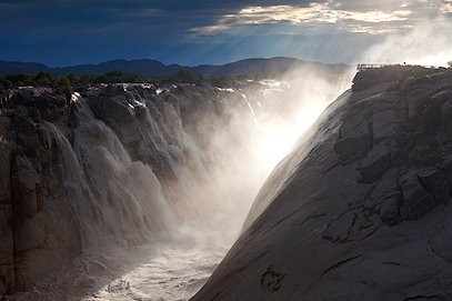
Spray and thunder at Augrabies Falls viewpoint

Sensory Overload

Experiencing the might of the waterfall stays with you: the ground shudders, the thunder rolls, and cool spray drifts across the boardwalks—an unforgettable encounter with raw power.
Moon Rock and expansive views at Augrabies

Location, Location...

From Echo Corner and Oranjekrom to Ararat and Moon Rock, the viewpoints deliver superb, uncluttered vistas across one of South Africa’s most striking granite gorges.

Useful Information

History

The Augrabies Waterfall name derives from the Khoi word “Aukoerebis,” meaning “Place of Great Noise,” a reference to the Orange River thundering through the gorge and over the 56 m drop. People have lived here since the Early Stone Age; evidence includes tools, weapons, and primitive graves.

Today, the Nama people’s rounded “matjieshuise” or “mat houses” testify to ingenious adaptation: in summer the open weave allows cooling breezes; in winter the stems swell to insulate against the cold. The falls and surrounding desert landscape connect natural spectacle with living culture.

Wildlife

Augrabies is renowned for birding. Look for Verreaux’s eagle, pygmy falcon, pale chanting goshawk, rosy-faced lovebird, and an isolated population of Double-banded Sandgrouse. Rock hyrax are common on sunny ledges. Klipspringer, giraffe, eland, steenbok, springbok, gemsbok, and kudu occur, and the locally endemic Augrabies flat lizard is a sought-after sighting. Nocturnal highlights include aardwolf, bat-eared fox, African wild cat, spotted genet, and the elusive leopard.

Vegetation & Terrain

The Nama Karoo biome, though arid, is species-rich. Granite boulders and open shrublands frame immense gorges along the Orange River. Nearly 70 grasses, shrubs, herbs, and trees typify the area. The giant aloe provides vital summer nectar; camel thorn, sweet thorn, shepherd’s tree, and Namaqua fig form striking silhouettes at dusk.

Activities

Visit panoramic viewpoints—Augrabies Waterfall, Echo Corner, Moon Rock, Oranjekrom & Ararat, Swart Rante, and Arrow Point. The park is a birding hotspot; from Oranjekrom & Ararat, scan for Verreaux’s eagle hunting hyrax. Game and bird-viewing drives are popular, especially at night. Hikes, walks, and bike trails—including the three-day, 35.8 km Klipspringer Trail—offer expansive canyon and desert vistas.

Cool off in designated swimming pools during the heat of the day, or opt for adventure activities—such as hot-air ballooning and canoeing—by prior arrangement. Pack ample water, sun protection, and a hat; this region often experiences extreme heat.

Last Updated: November 21, 2025 Curated By: Riaan Viljoen